Fiery Cross Reef or North West Investigator Reef (9°35’N., 112°54’E.) lies 46nm northwest from Maralie Reef. China started occupying the reef since January 31, 1988 after its military ships successfully blocked Vietnam’s army engineers from entering the feature (1).
Based on Robert Beckman and Clive Schofield’ analysis of satellite imagery and previous studies, it can be interpreted that the nature form of Fiery Cross Reef is not an island defined by UNCLOS. It is also unclear whether it can be classified as rock or submerged feature.
China designated Fiery Cross Reef in 2011 as ”main command headquarters”. Photos of Fiery Cross Reef show a heliport, agricultural greenhouses and gun platforms. Images released by the Chinese Ministry of National Defense also show PLA marines in residence, coastal artillery, and a DP-65 anti-diver grenade launcher on the wharf (2)
International media reported that China started building artificial island on Fiery Cross in June 2014. The artificial island currently measures one square km, making it the largest island in the Spratly Islands. According to Taiwan media citing a Chinese military expert, the island would eventually measure 2 square km in area (3).
According to Article 60(8) of UNCLOS, however, “Artificial islands, installations and structures do not possess the status of islands. They have no territorial sea of their own, and their presence does not affect the delimitation of the territorial sea, the exclusive economic zone or the continental shelf.”
Below are photos showing the development of the reef since 1988.

China structures in South China Sea before its construction of artificial islands.

Fiery Cross Reef in 1988. China started installation of concrete platforms after occupying the reef.

Fiery Cross in November 2007 with a light house
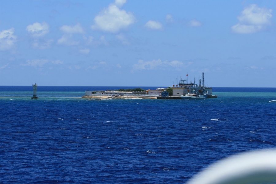
Fiery Cross in 2012

Facilities on Fiery Cross Reef before construction of the artificial island

The northeastern portion of Fiery Cross (Yongshu) Reef in the Spratly Islands shows no sign of land reclamation from March 2013 to April 2014. (PLEIADES CNES 2013, Distribution Airbus DS / Spot Image / IHS)

Image of Fiery Cross Reef, reportedly taken on September 20 and 25, 2014, showing an artificial island in the northern side of the reef.

Image of Fiery Cross Reef, reportedly taken in October 16, 2014, showing the artificial island was expanded.

Image of Fiery Cross Reef, reportedly taken in October 18, 2014, showing the artificial island.
Update on November 22, 2014

Satellite imagery dated 14 November 2014 shows the island has expanded almost the entire length of the reef. It is reportedly 3000 m long and between 200 and 300 m wide. According to IHS Jane’s report, multiple operating dredgers provide the ability to generate terrain rapidly. Operating from a harbour area, dredgers deliver sediment via a network of piping. (© CNES 2014, Distribution Airbus DS / Spot Image / IHS)
Reference:
(1) Vietnamese report on Spratlys situation in 1988: http://www.thanhnien.com.vn/pages/20141020/giu-truong-sa-truoc-tham-vong-ba-quyen-ky-4-nhung-cuoc-doi-dau-cang-thang.aspx
(2) More details emerge on China’s reclamation activities in Spratlys. IHS Jane’s Defence Weekly 04 July 2014: http://www.janes.com/article/40335/more-details-emerge-on-china-s-reclamation-activities-in-spratlys
(3) Mainland Launches Land Reclamation Project in the South China Sea: http://www.taiwannpfnews.org.tw/english/page.aspx?type=article&mnum=112&anum=15215
Sources of photos:
http://www3.nhk.or.jp/nhkworld/english/news/20140828_28.html

Discussion
Trackbacks/Pingbacks
Pingback: Indo-Pacific Review Points of Control: China’s Weiqi Strategy in the South China Sea - Indo-Pacific Review - November 15, 2014
Pingback: China’s Grand-Strategy Challenge: Creating Its Own Islands in the South China Sea | chinastrat.wordpress.com - December 8, 2014
Pingback: Fiery Cross Reef: Latest Photos and Developments | South China Sea Research - November 18, 2016